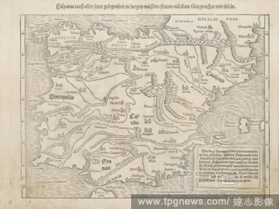
EditorialHispania, after all, is an opportunity in mountains, waters, cities, peoples, kingdoms and islands, Map of Spain from the 16th century, Fig. 5, according to S. v, 1544, Sebastian M?nster: Cosmographia. Beschreibung aller Lender durch Sebastianum M?nste...
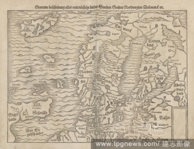
EditorialGeneral description of all central countries, Sweden, Goths, Nordwegien, Denmark etc., Map of Scandinavia from the 16th century, Fig. 13, according to S. viiii, 1544, Sebastian M?nster: Cosmographia. Beschreibung aller Lender durch Sebastianum M?nsteru...
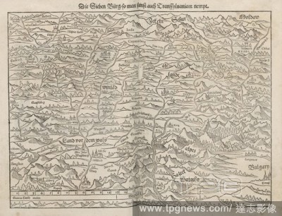
EditorialThe Seven Cities, so you also nempt Transsylvaniam, Map of the former Transylvania, today central Romania, from the 16th century, Fig. 16, according to S. vvii, 1544, Sebastian M?nster: Cosmographia. Beschreibung aller Lender durch Sebastianum M?nsteru...
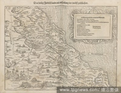
EditorialThe holy Judith ends up with a division of the twelfth gender, Map of Israel from the 16th century, Fig. 19, according to S. vv, 1544, Sebastian M?nster: Cosmographia. Beschreibung aller Lender durch Sebastianum M?nsterum: in welcher begriffen aller Vo...
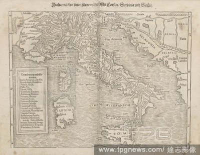
EditorialItalia with the third most islands Corsica, Sardinia and Sicilia, Map of Italy and the islands of Corsica., 16th century Sicily and Sardinia, Fig. 14, according to S. vv, 1544, Sebastian M?nster: Cosmographia. Beschreibung aller Lender durch Sebastianu...
EditorialSyria, Cyprus, Balestina, Mesopotamia, Babylonia, Chaldea, and two Arabia with mountains, water, stetten, Map of the Middle East from the 16th century, Fig. 18, after S. viv, 1544, Sebastian M?nster: Cosmographia. Beschreibung aller Lender durch Sebast...
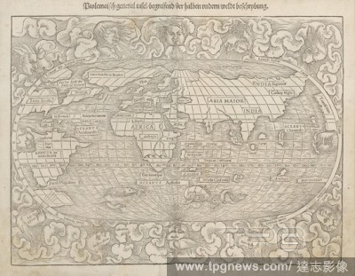
EditorialPtolemaic general panel, conceiving of the half andern weldt decryption., World map from the 16th century, Fig. 2, according to S. i, 1544, Sebastian M?nster: Cosmographia. Beschreibung aller Lender durch Sebastianum M?nsterum: in welcher begriffen all...
EditorialSchlesia at all costs in water, stetten, mountains and adjoining lenderen., Map of the former German Silesia, now Polish region around Wroclaw, from the 16th century, Fig. 12, after S. viii, 1544, Sebastian M?nster: Cosmographia. Beschreibung aller Len...
EditorialSiebenburg with all the surrounding countries, Map of the former Transylvania, today central Romania, and its surrounding lands from the 16th century, Fig. 36, according to S. DLIII, 1544, Sebastian M?nster: Cosmographia. Beschreibung aller Lender durc...
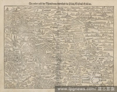
EditorialThe other table of the Rheinstroms including the Bfaltz, Westrich, Enfel etc., Map of the Rhine in the area Pfaltz from the 16th century, Fig. 8, according to S. iv, 1544, Sebastian M?nster: Cosmographia. Beschreibung aller Lender durch Sebastianum M?n...
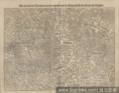
EditorialThe first panel of the Rhine current, in the out of print, the Eidtgnoschafft Alsace and Brisg?w, Map of the Rhine in the area of Brisgau, the Alsace and Black Forest from the 16th century, Fig. 7, according to S. viii, 1544, Sebastian M?nster: Cosmogr...
EditorialLibyan lion, Illustration of a Lybian lion from the 16th century, Fig. 38, according to S. DCXLIIII, 1544, Sebastian M?nster: Cosmographia. Beschreibung aller Lender durch Sebastianum M?nsterum: in welcher begriffen aller Voelker, Herrschaften, Stetten...
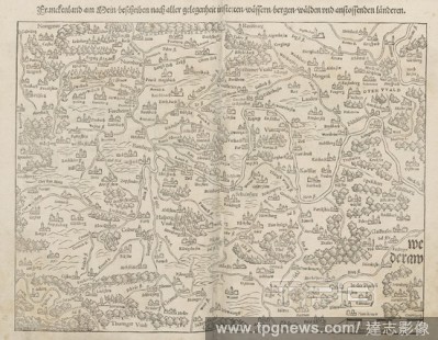
EditorialFrankenland on the Rhine, write innstetten, water, mountains, forests and adjoining countries after all possible, Map of northern Bavaria and the Rhine from the 16th century, Fig. 11, according to S. vii, 1544, Sebastian M?nster: Cosmographia. Beschrei...
EditorialAfrica, Libya, Norland, with all the kingdoms so found in our times, Map of Africa from the 16th century, Fig. 22, after S. vviii, 1544, Sebastian M?nster: Cosmographia. Beschreibung aller Lender durch Sebastianum M?nsterum: in welcher begriffen aller ...
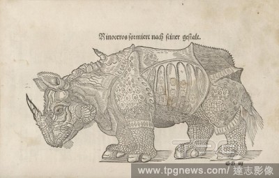
EditorialRhino forms after his form, Illustration of a rhinoceros from the 16th century, Fig. 37, according to S. DCXXX, 1544, Sebastian M?nster: Cosmographia. Beschreibung aller Lender durch Sebastianum M?nsterum: in welcher begriffen aller Voelker, Herrschaft...
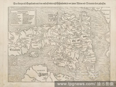
EditorialThe kingdom of Engingen with the adjoining Rich Schittlandt was called before Allbion and Brittania han, Map of England and Scotland from the 16th century, Fig. 4, according to S. iiii, 1544, Sebastian M?nster: Cosmographia. Beschreibung aller Lender d...
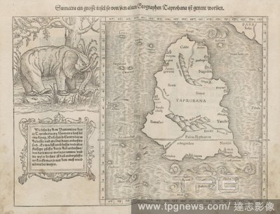
EditorialSumatra a big island so by the ancient geographers Laprobana has been genent, Map of Sumatras from the 16th century, Fig. 20, according to S. vvi, 1544, Sebastian M?nster: Cosmographia. Beschreibung aller Lender durch Sebastianum M?nsterum: in welcher ...
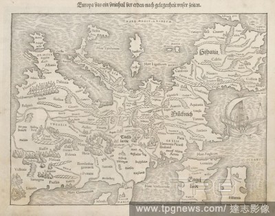
EditorialEurope the third part of the earth, on the occasion of our times, European map with Spain, France, and England from the 16th century, Fig. 3, according to p. Iii, 1544, Sebastian M?nster: Cosmographia. Beschreibung aller Lender durch Sebastianum M?nste...
EditorialNeuw Greece with other adjoining countries, as it is described in our times., Map of Greece from the 16th century, Fig. 17, according to S. vviii, 1544, Sebastian M?nster: Cosmographia. Beschreibung aller Lender durch Sebastianum M?nsterum: in welcher ...
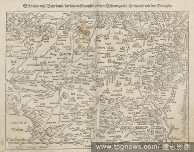
EditorialSwabians and Baier land, including the Black Forest, Otenwald and the Nordg?w, Map of Schwabens and Bavaria from the 16th century, Fig. 10, according to S. vi, 1544, Sebastian M?nster: Cosmographia. Beschreibung aller Lender durch Sebastianum M?nsterum...
EditorialTeutsch lands with his whole concept and in-depth country estates, Map of Germany from the 16th century, Fig. 6, according to S. vii, 1544, Sebastian M?nster: Cosmographia. Beschreibung aller Lender durch Sebastianum M?nsterum: in welcher begriffen all...
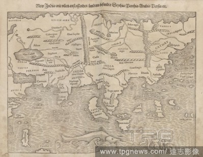
EditorialNew India, with many adjoining countries, besenters Senthia, Barchia, Arabia, Bersia, Map of Asia from the 16th century, Fig. 21, according to S. vvii, 1544, Sebastian M?nster: Cosmographia. Beschreibung aller Lender durch Sebastianum M?nsterum: in wel...
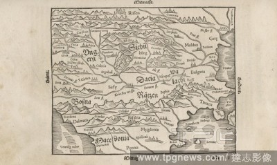
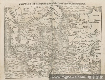
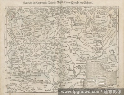
EditorialCountry board of Ungerland, Bolands, Ruffen, Littaw, Wallachia and Bulgarei, Map of the entire Eastern Europe from the 16th century, Fig. 15, according to S. vvi, 1544, Sebastian M?nster: Cosmographia. Beschreibung aller Lender durch Sebastianum M?nste...
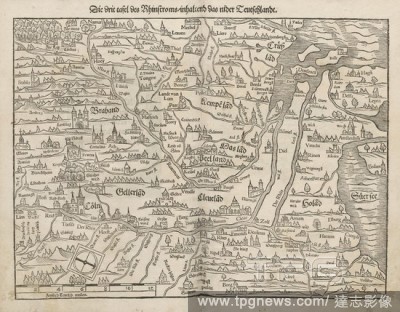
EditorialThe third panel of the Rhine river, containing the low Teutschland, Map of the Rhine in the area of Cologne, D?sseldorf and Holland from the 16th century, Fig. 9, according to S. v, 1544, Sebastian M?nster: Cosmographia. Beschreibung aller Lender durch...


 Loading