
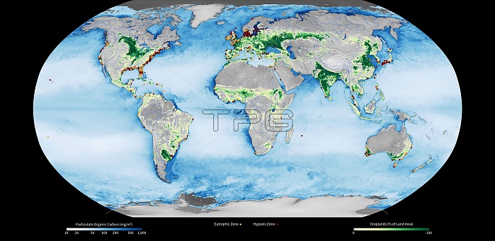
Coastal dead zones, global satellite map
| px | px | dpi | = | cm | x | cm | = | MB |
Details
Creative#:
TOP18613217
Source:
達志影像
Authorization Type:
RM
Release Information:
須由TPG 完整授權
Model Release:
No
Property Release:
No
Right to Privacy:
No
Same folder images:
GLOBALMAPDEADZONEALGAEALGALBLOOMEARTHGEOGRAPHYEARTHOBSERVATIONPHYSICALGEOGRAPHYENVIRONMENTALSCIENCEOCEANOGRAPHYSATELLITEIMAGEMAPFROMSPACEGRAPHICSATELLITEVIIRSNPPSUOMI21STCENTURY2013AGRICULTURALAGRICULTUREBLACKBACKGROUNDCOASTCOASTALCOLOR-CODEDCOLOUR-CODEDCROPLANDCROPLANDSCROPSDEADFISHDEADZONESEUTROPHICATIONEUTROPICZONEEUTROPICZONESFARMINGFERTILISERFERTILISERSGEOGRAPHICALGLOBALHUMANIMPACTHYPOXIAHYPOXICZONEHYPOXICZONESKEYKILLEDLABELLABELEDLABELLEDMARINEDESERTSNATIONALPOLARORBITINGPARTNERSHIPNATIONALPOLAR-ORBITINGPARTNERSHIPNO-ONENOBODYOXYGENDEPLETIONPARTICULATEORGANICCARBONPOCPSEUDOCYLINDRICALPROJECTIONSCALETEXTLABELSVIMSVIRGINIAINSTITUTEOFMARINESCIENCEVISIBLEINFRAREDIMAGINGRADIOMETERSUITEWATERQUALITYWORLDWORLDRESOURCESINSTITUTEWORLDWIDEWRIBLOOMS
201321STAGRICULTURALAGRICULTUREALGAEALGALBACKGROUNDBLACKBLOOMBLOOMSCARBONCENTURYCOASTCOASTALCOLOR-CODEDCOLOUR-CODEDCROPLANDCROPLANDSCROPSDEADDEADDEADDEPLETIONDESERTSEARTHEARTHENVIRONMENTALEUTROPHICATIONEUTROPICEUTROPICFARMINGFERTILISERFERTILISERSFISHFROMGEOGRAPHICALGEOGRAPHYGEOGRAPHYGLOBALGLOBALGRAPHICHUMANHYPOXIAHYPOXICHYPOXICIMAGEIMAGINGIMPACTINFRAREDINSTITUTEINSTITUTEKEYKILLEDLABELLABELEDLABELLEDLABELSMAPMAPMARINEMARINENATIONALNATIONALNO-ONENOBODYNPPOBSERVATIONOCEANOGRAPHYOFORBITINGORGANICOXYGENPARTICULATEPARTNERSHIPPARTNERSHIPPHYSICALPOCPOLARPOLAR-ORBITINGPROJECTIONPSEUDOCYLINDRICALQUALITYRADIOMETERRESOURCESSATELLITESATELLITESCALESCIENCESCIENCESPACESUITESUOMITEXTVIIRSVIMSVIRGINIAVISIBLEWATERWORLDWORLDWORLDWIDEWRIZONEZONEZONEZONESZONESZONES
 Loading