
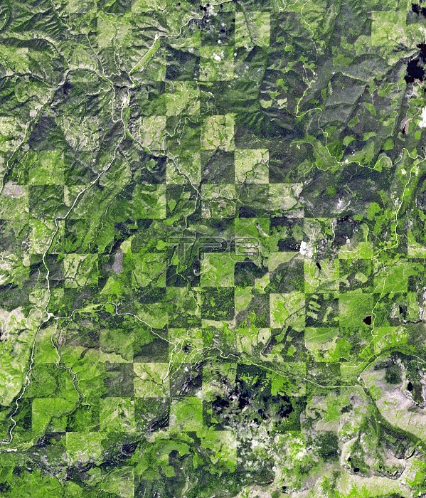
Logging pattern. Satellite image showing the checkerboard pattern left by logging operations along the Idaho-Montana border, between Clearwater and Bitterroot National Forests, USA. Each 1x1 mile square seen here is harvested at a different time, producing a pattern of varied timber density and re-growth stages. Imaged by the ASTER (Advanced Spaceborne Thermal Emission and Reflection Radiometer) instrument onboard NASA's Terra satellite, on 30th July 2012.
| px | px | dpi | = | cm | x | cm | = | MB |
Details
Creative#:
TOP14563628
Source:
達志影像
Authorization Type:
RM
Release Information:
須由TPG 完整授權
Model Release:
N/A
Property Release:
No
Right to Privacy:
No
Same folder images:
201221stcentury30july30/07/201230thadvancedspacebornethermalemissionandreflectionradiometeramericanasterbitterootnationalforestcheckerboardclearwaterdensityearthobservationfarmingforestforestsfromabovefromspacegeographicalgeographygrowthidahoindustrialindustryjulylanduseloggedloggingmanagementmontanano-onenobodynorthamericapatternpatternedpatternspracticepracticesre-growthsatelliteimagesquaresquaresstagestagesterrasatellitetimberunitedstatesus
30201221st30/07/201230thaboveadvancedamericaamericanandasterbitterootcenturycheckerboardclearwaterdensityearthemissionfarmingforestforestforestsfromfromgeographicalgeographygrowthidahoimageindustrialindustryjulyjulylandloggedloggingmanagementmontananationalno-onenobodynorthobservationpatternpatternedpatternspracticepracticesradiometerre-growthreflectionsatellitesatellitespacespacebornesquaresquaresstagestagesstatesterrathermaltimberunitedususe
 Loading