
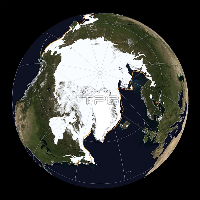
Arctic sea ice maximum, 2014. Arctic sea ice reached its maximum extent for 2014 on 21 March at 14.91 million square kilometres. This was the fifth lowest maximum in the satellite record (started 1978). This image was produced by the National Snow and Ice Data Center (NSIDC) using Sea Ice Index data. This is based on microwave data from the F17 Special Sensor Microwave Imager/Sounder (SSMIS), part of the Defense Meteorological Satellite Program (DMSP).
| px | px | dpi | = | cm | x | cm | = | MB |
Details
Creative#:
TOP13790064
Source:
達志影像
Authorization Type:
RM
Release Information:
須由TPG 完整授權
Model Release:
N/A
Property Release:
No
Right to Privacy:
No
Same folder images:
201421march201421stcenturyarcticballblackbackgroundcentreclimatechangeclimatologicalclimatologycutoutcutoutscut-outcut-outscutoutcutoutsdefencedefensemeteorologicalsatelliteprogramdmspearthearthobservationearthsciencesenvironmentalsciencefifthlowestfromspacegeographicalgeographyglaciologyglobalwarmingglobeicecapmaximummaximumextentnationalsnowandicedatacenterno-onenobodynorthpolenorthernhemispherenorthernpolarregionnsidcplanetplanetarysatelliteimageseaicespecialsensormicrowaveimagersounderspheresphericalspringssmiswinter
212014201421standarcticbackgroundballblackcapcentercentrecenturychangeclimateclimatologicalclimatologycutcutcut-outcut-outscutoutcutoutsdatadefencedefensedmspearthearthearthenvironmentalextentfifthfromgeographicalgeographyglaciologyglobalglobehemisphereiceiceiceimageimagerlowestmarchmaximummaximummeteorologicalmicrowavenationalno-onenobodynorthnorthernnorthernnsidcobservationoutoutsplanetplanetarypolarpoleprogramregionsatellitesatellitesciencesciencesseasensorsnowsounderspacespecialspheresphericalspringssmiswarmingwinter
 Loading