
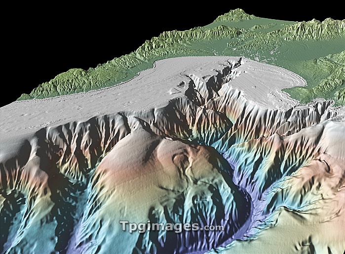
Monterey bay. 3-D satellite and bathymetry image of Monterey bay, USA. It was produced using GeoMapApp, a geophysical visualisation program at the Lamont-Doherty Earth Observatory of Columbia University, USA, using data from the Shuttle Radar Topographic Mission (SRTM) and shipboard bathymetry measurments. The image shows seafloor topography (lower half) and land topography (upper half).
| px | px | dpi | = | cm | x | cm | = | MB |
Details
Creative#:
TOP07420208
Source:
達志影像
Authorization Type:
RM
Release Information:
須由TPG 完整授權
Model Release:
NO
Property Release:
NO
Right to Privacy:
No
Same folder images:
northamericausamontereybaycaliforniaearthobservationgeographygeologyspaceflightradarimagingbathymetryshuttleradartopographicmissionsrtmmultibeambathymetry3-d3damericanbaycanyoncomputervisualisationcomputervisualizationgeographicalgeologicalgeomappappseafloorsubmarinetopographyunderwaterunderwaterunitedstates
3-d3damericaamericanbathymetrybathymetrybaybaycaliforniacanyoncomputercomputerearthgeographicalgeographygeologicalgeologygeomappappimagingmissionmontereymultibeamnorthobservationradarradarseafloorshuttlespaceflightsrtmstatessubmarinetopographictopographyunderunderwaterunitedusavisualisationvisualizationwater
 Loading